There’s an old saying in farm country, that when times are tough, it’s time to tighten up the belt. But to which belt do they refer? With so many different kinds of agriculture pressure giving producers the heebie geebies, the belt in which they live and operate may determine what needs tightened. The U.S. has long described its geographic regions as beltways, and to that extent we’ve all heard of the following: the Corn Belt, Wheat Belt, Cotton Belt, Rust Belt, and Sun Belt.
Obviously there’s a lot of crossover here, with many rural states belonging to more than one grouping. Not to mention that folks may have different ideas of the exact boundaries of each belt. Meanwhile, other belts are as different as snow and sand.
As all producers know, geography matters. What are the most pressing issues facing the rural communities in these belts? Read below for a run-down and interesting facts concerning America’s belts:
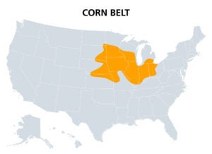
The Corn Belt
Ostensibly defined as the upper and middle Midwest, discussions about the Corn Belt states typically include: Iowa, Illinois, Indiana, Ohio, Nebraska, Kansas, Minnesota, and sometimes parts of both North and South Dakota as well as Kentucky. The population of those states combined equals about 55 million people. Big issues facing corn producers recently include higher interest rates on financing and pressure on banks.
Corn Belt states do double as producers of other agricultural commodities, but this Midwestern zone is responsible for the U.S. leading global production of corn year after year. About 61 percent of U.S. corn is produced in Iowa, Illinois, Nebraska, Minnesota, and Indiana alone, and U.S. output represents 30 percent of the Earth’s production (despite the U.S. having less than 2 percent of the Earth’s dry land). In addition to livestock feed, corn is used for a myriad of industrial purposes ranging from fuel to human medicine.
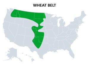
The Wheat Belt
Primarily more of a vertical belt, this strip of states run north-south about 1,500 miles from central Canada to central Texas, including the states of Kansas, Oklahoma, Nebraska, Colorado, Montana, North and South Dakota, and Minnesota. The total population of this region amounts to about 23 million people.
A staple crop as ancient as the human species, the world leans heavily upon wheat as one of it’s primary cereals. The Wheat Belt earns its name as America’s biggest source of the crop, and one that keeps the country among the top producers in the world, most recently about fifth globally with 6 percent of Earth’s production.
About 58 percent of U.S. wheat comes from Kansas, North Dakota, Montana, Washington, and Oklahoma, with Kansas alone producing 18 percent. In addition to the actual wheat used to make flour, all farm folks know that wheat is used to also make straw. One of the most versatile commercial crops, wheat is used in pasta, crackers, starch, paste, malt, dextrose, gluten, and alcohol.
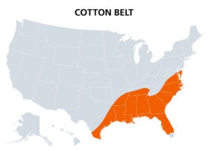
The Cotton Belt
A region of historic significance to the U.S., the Cotton Belt today extends east to west, from North and South Carolina, through Georgia, Alabama, Mississippi, Tennessee, Arkansas, Louisiana, eastern Texas, and, depending on the map, southern Oklahoma. One of the original crops produced by the American colonies even before the Revolutionary War, the uses for cotton span the history of human civilization. And just like other crops, cotton requires a specific climate and soil type, really only found in the southern belt of states.
Ideal temperatures for the crop are near 80 degrees, with 60 to 80 inches of annual rainfall, which describes the spread of land between Georgia and east Texas.
The U.S. remains a world leader in the production of cotton, placing third behind China and India. Of that, 75 percent of American cotton comes from Texas, Georgia, Mississippi, Arkansas, and Alabama respectively. In addition to cotton’s use in clothing, the crop also produces a seed oil that can be made into cosmetics, coffee filters, oil, rubber, and plastics.
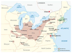
The Rust Belt
A belt discussed in the news with frequency is the Rust Belt, which runs southwesterly from south and central New York through Pennsylvania, Ohio and parts of West Virginia, Kentucky, northern Indiana, and then up through lower Michigan and northern Illinois, and a bit of southeastern Wisconsin. Unlike the agricultural belts which are defined by rural zones, the Rust Belt is better defined by the major metropolitan areas around which the rural zones circle. Cities like Rochester, New York; Newark, New Jersey; Pittsburgh, Pennsylvania; Detroit, Michigan; and Gary, Indiana, are familiar to those following the economy as it pertains to heavy manufacturing.
The Rust Belt states double as major agricultural producers and the relationship between industry and farming soups together like sausage and gravy across the biscuit that is America. This relationship is manifest in the history of agricultural technological innovations from tractors to seeds as these centers of industry are where those products were created.
Residents in these areas have been experiencing declines in economic activity and population since the 1960s, with their peak output considered be in the earlier decades of the 20th century up through the 1950s. Consider in 1950 the population of Detroit stood at 1.8 million, but in 2020 it was 639,111, representing a change of -32.81 percent. Gary, Indiana, likewise has gone from 178,320 in 1960 to 69,903 in 2020, for a change of -31.97 percent. Pittsburgh’s 1950 population was 676,806 and fell to 302,971 in 2020.
The good news is agricultural technology is still a driving force in these communities and where hope remains for their economy it remains in the knowledge-based industries that, yes, include farming systems.
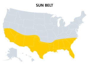
The Sun Belt
And on the other side of the country we have the Sun Belt, which faces problems opposite the Rust Belt, many of which involve population expansion. Typically described as the 15 southern states extending from sea to shining sea, the Sun Belt runs from North Carolina to Florida and then west to California. If you’re wondering where the population that left the Rust Belt went, consider that the South grew in population by 36 percent between 1970 and 1990, and the Western states by 51 percent. In 1970, about 48 percent of the U.S. population lived in the South and West. According to the 2020 U.S. Census, that percentage has now jumped to 62 percent.
Immigration from other countries has contributed mightily to these numbers as well, and agriculture is a huge part of these states’ economies. The state of California alone produces 400 different agricultural commodities, with 75 percent of the U.S. fruits and nuts produced there.
But the big concern amid Sun Belt states, particularly those in the West, is lack of water. In addition to drought and climate change, the increased population in those areas have stressed aquifers to the max. Meanwhile, the effects of climate change and population increases are also being felt in the Deep South.
Economically though, this Sun Belt has unquestionably picked up the industrial output once generated in the Rust Belt by way of digital technology such as that in Silicon Valley, to the agricultural technology now associated with artificial intelligence and computers.
Tightening the Belts
If you consider yourself to be a part of rural Americana, chances are you live in one or more of these belts. Common denominators include patriotism, music, and community pride. If these appeal to you, reach out to well-reviewed movers and start planning your big move.
Whether the economy is booming or shrinking largely depends on your own perspective, and in which belt you happen live. What’s interesting though is the other big common denominator, which is agricultural production. Whether a manufacturing state that produces tractors, or a rural state growing cotton, walnuts, or wheat, irrespective the weather and soil type differences, people need food and fiber. And whether they wear belts made of cow’s leather, or perhaps hemp, the belts that wrap about America are ag through and through.
Brian Boyce is an award-winning writer living on a farm in west-central Indiana. You can see more of his work at the Boyce Group homepage.


