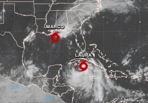
While the year 2020 will already go down in history for many reasons — the coronavirus pandemic, murder hornets, and a derecho in Iowa — we can also add rare back-to-back tropical storms making landfall in the United States.
Marco is the first storm hitting the mainland in this historic event. Although Marco is no longer categorized as hurricane and downgraded to a tropical storm, it will still bring rainfall, gusty winds, and storm surges to Louisiana and the northern Gulf Coast late Monday evening.
Laura is the second storm and is actually predicted to intensify into a hurricane later this week. As of right now, the forecast shows it to hit the mainland by midweek along the Louisiana and Texas coasts, but the forecast can still change.

Thankfully, The Weather Channel states that although close, these two storms will not merge. “Despite the two cones crossing paths, these storms will not merge together. Instead, it’s increasingly likely that Laura could follow Marco and make landfall back-to-back over a similar region just days apart,” the network said.
This is a rare occurrence to have so much activity in the Gulf of Mexico. According to Dr. Phil Klotzbach from Colorado State University, it will be the first time since the 1950s that two tropical storms have been simultaneously active in the Gulf of Mexico.
These events will have major impacts for farmers and ranchers in the path of the storms. Farmers are working against the clock to harvest as much as their crop as possible. In a Facebook post the Louisiana Farm Bureau Federation said, “Hurricane Marco is on track to make landfall in Southeastern Louisiana Monday evening. Laura is expected to follow 48 hours later with landfall near the Sabine River, possibly as a category two hurricane. This happens as Louisiana farmers are harvesting rice, corn and soybeans and planting sugarcane.
On Facebook, RCM Ag Services posted a photo with Louisiana farmers helping each other out in preparation of the storms to come.
Louisiana Department of Agriculture and Forestry Commissioner Mike Strain also said livestock and pet owners should make preparations ahead of possible severe weather and flooding caused by tropical systems Laura and Marco and be prepared to evacuate if necessary.
“While the track of these storms remains somewhat uncertain, forecasters say the main threat is heavy rainfall and coastal flooding due to storm surge,” Strain said. “Citizens should be prepared for an extended period of severe weather with little or no window between storms. Livestock and pet owners should be ready to evacuate if necessary.”
Strain gave the following tips for livestock:
- Get cattle to the highest ground on your property that can allow access to trailers and vehicles if animals need to be moved.
- Valuable breeding stock should be identified and moved in accordance with the owner’s evacuation plan. Those animals should be kept closer to the homestead for easier transport.
- If a large group of cattle is to be moved, it is important that each herd member is properly identified with brands, microchips or ear tags. Identify the ultimate evacuation location for livestock. Proper identification for livestock is crucial in the event of commingling. Check trailer tail lights and tires.
- If you shelter in place, be sure to have at least a five day supply of water and hay for cattle.
- Plan to carry at least five days of food for your animals on livestock transports, especially if the animals require a specially-formulated diet.
- Horses must have a permanent identification, like a microchip, brand or lip tattoo.
- Horse owners should bring all identification papers if evacuation is necessary along with a copy of the horse’s current Coggins test record.
- Horse owners should also carry recent photographs of their horses (including identifying marks).


